- Αρχική Σελίδα /
- Ηλεκτρονικά /
- Ηλεκτρονικά Αυτοκινήτων & Οχημάτων /
- Marine Electronics /
- Marine GPS Chartplotters /
- Weems & Plath Marine Navigation GPS Plotter
0 ratings


Προϊόν #:
25178446
Weems & Plath Marine Navigation GPS Plotter
Προϊόν #:
25178446
€ 84
Price Details
Excluding Shipping & Custom charges ( Shipping and custom charges will be calculated on checkout )
*All items will import from ΗΠΑ
0 ratings
Γράψτε μια κριτική
Σε απόθεμα
QTY:
Μόνο 6 προϊόντα έχουν απομείνει σε απόθεμα.
Παραγγείλτε τώρα και πάρτε το περίπου: Τετάρτη, Ιούλιος 08
Secured transaction
Ubuy works hard to protect your security and privacy. Our advanced payment security system ensures confidentiality by encrypting your information during transmission using AES (Advanced Encryption Standards) and SSL (Secure Socket Layer) protocols. Your payment details are 100% secure as we do not share your payment details with third party sellers.
Our Top Logistics Partners
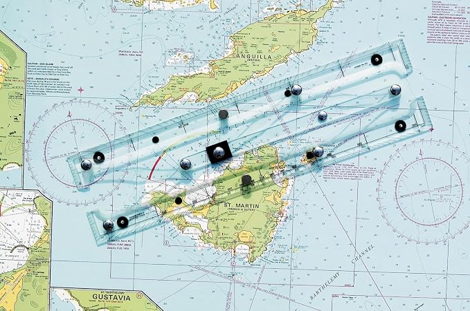
Quickly, easily, and accurately plot your GPS coordinates on a paper chart with our GPS Plotter.
Fast
Shipping
Free
Return*
Secure Packaging
100% Original Products
PCI DSS Compliance

ISO 27001 Certified
Note: Step Down Voltage Transformer required for using electronics products of ΗΠΑ store (110-120). Recommended power converters Αγορασε τωρα.


Λεπτομέρειες προιόντος
- 15-1/2 inches (39.37cm) long
- Innovative straight-line action
- Pencil guide holes
- Sturdy clear acrylic & stainless steel/brass construction
- Non-slip pads
- Protractor & parallel rule features
- Instructions on back of protective plastic sleeve
| Compatible with Vehicle Type | Boat |
| Additional Features | Effective Interface |
| Map Types | Nautical |
| Mounting Type | Panel Mount |
| Touch Screen Type | Resistive |
| Display Type | touch screen |
| Human-Interface Input | Buttons |
| Compatible Devices | Smartphone, Tablet |
| Control Method | Touch |
| Are Batteries Included | No |
| Supported Satellite Navigation System | GPS |
| Sport Type | Boating |
| Brand | WEEMS-AND-PLATH |
| Model Name | 130 |
| UPC | 721002001849 |
| Global Trade Identification Number | 00721002001849 |
| Manufacturer | Weems & Plath |
| Model Number | 130 |
| Mfr Part Number | 130 |
| Item Dimensions L x W x H | 15.5"L x 3"W x 0.66"H (39.4 x 7.6 x 1.7 cm) |
| Item Weight | 1.3 Pounds (590 grams) |
| Vehicle Service Type | Boat |
| Special Feature | Effective Interface |
| Map Type | Nautical |
| Product Dimensions (L x W x H) | 15.5"L x 3"W x 0.66"H (39.4 x 7.6 x 1.7 cm) |
ΠΕΡΙΓΡΑΦΗ ΤΟΥ ΠΡΟΪΟΝΤΟΣ
Έχετε κάποιο ερώτημα; Συνομιλήστε μαζί μας
Ερωτήσεις & Απαντήσεις Πελατών
-
ερώτηση:
What features does the Weems & Plath Marine Navigation GPS Plotter offer?
απάντηση: The Weems & Plath Marine Navigation GPS Plotter boasts advanced features such as precise GPS tracking, easy-to-read display options, and customizable waypoints. Designed for marine navigation, this plotter helps sailors navigate with confidence by providing clear maps and real-time positioning data. With integrated tools for route planning, users can chart their course effectively, making it a valuable asset for both recreational boaters and professional mariners. -
ερώτηση:
Is the Weems & Plath Marine Navigation GPS Plotter user-friendly?
απάντηση: Yes, the user interface of the Weems & Plath Marine Navigation GPS Plotter is designed to be intuitive and accessible even for novice users. The touch screen feature allows for easy navigation through menus and settings, which is essential when out at sea. This GPS plotter has customizable display options, making it suitable for various lighting conditions, and ensuring that all users can operate it with minimal training. -
ερώτηση:
Can the Weems & Plath GPS Plotter provide real-time weather updates?
απάντηση: The Weems & Plath Marine Navigation GPS Plotter does not inherently provide real-time weather updates; however, it can integrate with compatible devices or apps that do. The importance of weather conditions cannot be overstated in marine environments, and by connecting to weather services, users can monitor changes and make informed decisions during their voyages, enhancing safety on the water. -
ερώτηση:
What types of maps does the Weems & Plath GPS Plotter support?
απάντηση: The Weems & Plath Marine Navigation GPS Plotter supports various maritime map types, including vector charts and raster charts. This flexibility ensures users can access the most relevant and up-to-date navigational information for their specific sailing area. Many boaters prefer vector charts for their accuracy and detail, while raster charts provide historical data, catering to diverse navigational needs. -
ερώτηση:
How does the Weems & Plath GPS Plotter assist in route planning?
απάντηση: The Weems & Plath Marine Navigation GPS Plotter simplifies route planning by allowing users to set waypoints and create paths directly on its interface. The plotting software can calculate the distance and estimated travel time, enabling sailors to plan their journeys more effectively. This capability is crucial for long-distance voyages, where precise navigation can make all the difference in safety and efficiency. -
ερώτηση:
What is the battery life of the Weems & Plath Marine Navigation GPS Plotter?
απάντηση: The battery life of the Weems & Plath Marine Navigation GPS Plotter is designed to support extended use without interruption. While specifics can vary based on operational settings, users typically find the battery performs well for prolonged periods, making it suitable for day trips or longer excursions. Ensuring that the device is adequately charged before setting out is essential for continuous navigation and access to critical information while on the water. -
ερώτηση:
Can I use the Weems & Plath GPS Plotter for both inland and offshore navigation?
απάντηση: Yes, the Weems & Plath Marine Navigation GPS Plotter is versatile enough for both inland and offshore navigation. Its comprehensive mapping capabilities allow users to navigate various waterways confidently. This multifunctionality makes it ideal for recreational boaters who explore lakes and rivers as well as for those sailing in coastal environments, ensuring reliable performance in diverse settings. -
ερώτηση:
Does the Weems & Plath GPS Plotter support Bluetooth connectivity?
απάντηση: The Weems & Plath Marine Navigation GPS Plotter typically does not include Bluetooth connectivity, focusing instead on providing reliable GPS navigation without additional wireless features. Nonetheless, it can connect to external devices such as AIS transponders for better situational awareness. This ensures that every boater has the tools needed to stay informed about other vessels in the vicinity while navigating. -
ερώτηση:
Are updates available for the Weems & Plath Marine Navigation GPS Plotter?
απάντηση: Yes, users can access updates for the Weems & Plath Marine Navigation GPS Plotter to enhance functionality and support newer navigation technologies. Keeping the software up to date is crucial for ensuring optimal performance and access to the latest maritime charts. Regular updates can improve features and provide usability enhancements, making it a reliable tool for any maritime journey. -
ερώτηση:
Where can I buy the Weems & Plath Marine Navigation GPS Plotter in Cyprus?
απάντηση: You can purchase the Weems & Plath Marine Navigation GPS Plotter in Cyprus at Ubuy. Ubuy offers a reliable online platform where you can find this product and have it delivered straight to your location, ensuring easy access for all your navigation needs.
WEEMS & PLATH Marine GPS Chartplotters 130 Editorial Review
The Weems & Plath Marine Navigation GPS Plotter offers a great concept, but falls short in terms of construction quality. The arms and hinge points that establish the parallels are flimsy and fail to maintain accurate navigation. Although it is good enough for general area navigation, it is not suitable for specific location accuracy. Some units have arrived with missing support-feet and slight twists, while others have issues with misaligned ruler markings and unreadable instructions. The responsibility for these faults lies with the manufacturer, Weems & Plath, as the quality of their packaging and the misaligned markers are a result of their Q&A department. Despite these flaws, the product functions as listed and some customers would consider buying it again.
Customer Reviews & Ratings
9 βαθμολογίες πελατών
-
5 αστέρι
61%
-
4 αστέρι
10%
-
3 αστέρι
17%
-
2 αστέρι
0%
-
1 αστέρι
12%
Αξιολογήστε αυτό το προϊόν
Κοινοποιήστε τις σκέψεις σας με άλλους πελάτες
Πλεονεκτήματα
- Great concept
- Functions as listed
- Arrived on time
Μειονεκτήματα
- Flimsy construction
Product Price History
Σημαντικές πληροφορίες
- Περιορισμοί : Για προϊόντα που αποστέλλονται διεθνώς, σημειώστε ότι τυχόν εγγύηση του κατασκευαστή ενδέχεται να μην είναι έγκυρη, οι επιλογές εξυπηρέτησης του κατασκευαστή ενδέχεται να μην είναι διαθέσιμες, τα εγχειρίδια, οι οδηγίες και οι προειδοποιήσεις ασφαλείας του προϊόντος ενδέχεται να μην είναι στη γλώσσα της χώρας προορισμού, τα προϊόντα (και τα συνοδευτικά υλικά) ενδέχεται να μην είναι σχεδιασμένα σύμφωνα με τα πρότυπα, τις προδιαγραφές και τις απαιτήσεις επισήμανσης της χώρας προορισμού και τα προϊόντα ενδέχεται να μην συμμορφώνονται με την τάση και άλλα ηλεκτρικά πρότυπα της χώρας προορισμού (απαιτώντας τη χρήση προσαρμογέα ή μετατροπέα, εάν χρειάζεται). Ο παραλήπτης είναι υπεύθυνος να διασφαλίσει ότι το προϊόν μπορεί να εισαχθεί νόμιμα στη χώρα προορισμού. Όταν παραγγέλνετε από το Ubuy ή τις θυγατρικές της, ο παραλήπτης είναι ο εισαγωγέας αρχείου και πρέπει να συμμορφώνεται με όλους τους νόμους και τους κανονισμούς της χώρας προορισμού.
- Δεν είναι όλα τα προϊόντα που παρατίθενται στο Ubuy προς πώληση, καθώς το Ubuy είναι μια παγκόσμια μηχανή αναζήτησης. Τα προϊόντα υπόκεινται σε κανονισμούς εξαγωγής/εμπορίου.
€ 84
Παραγγείλτε τώρα και πάρτε το περίπου: Τετάρτη, Ιούλιος 08
This item is not restrict in my country.(Please click on above link if this item is not restrict in your country, So our team will review and allow.)
QTY:
Μόνο 6 προϊόντα έχουν απομείνει σε απόθεμα.
Secured transaction
Ubuy works hard to protect your security and privacy. Our advanced payment security system ensures confidentiality by encrypting your information during transmission using AES (Advanced Encryption Standards) and SSL (Secure Socket Layer) protocols. Your payment details are 100% secure as we do not share your payment details with third party sellers.
Our Top Logistics Partners
Fastest cross-border delivery
Χαρακτηριστικά & Πλεονεκτήματα
- Simplified two-step maneuver for plotting GPS coordinates.
- Compatible with any paper chart for versatile use.
- Designed for accuracy in latitude and longitude plotting.
- User-friendly interface for anyone, regardless of experience.
- Enhances traditional navigation methods with modern technology.
- Essential tool for sailors and outdoor enthusiasts.